 EMODnet Product Catalogue
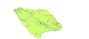
DOP/IMAR University of the Azores
Type of resources
Available actions
Topics
Keywords
Contact for the resource
Provided by
Formats
Representation types
Update frequencies
status
Scale 1:
-
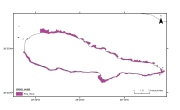
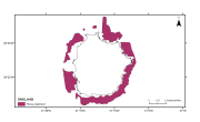
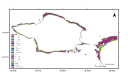
Map derived from the work presented by F.Tempera and coleagues on the Condor seamount, near Faial Island in the Azores. High-resolution datasets collected by multibeam and acoustic backscatter surveys were used to produce fine-scale seafloor nature and morpho-tectonic interpretations of the seamount, collected from various acoustic surveys from 2008 to 2010. submitted in Fernando Tempera, Ana Hip├│lito, Jos├® Madeira, Sara Vieira, Aldino S. Campos, Neil C. Mitchell, Condor seamount (Azores, NE Atlantic): A morpho-tectonic interpretation, Deep-Sea Research II, http://dx.doi.org/10.1016/j. dsr2.2013.09.016
-
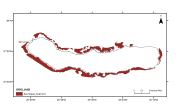
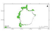
Interpretation of backscatter mosaics and seismic sub-bottom profiles. Tempera, F., M. McKenzie, I. Bashmachnikov, M. Puotinen, R.S. Santos & R. Bates (2012). Predictive modelling of dominant macroalgae abundance on temperate island shelves (Azores, northeast Atlantic). In Baker, E. and P. Harris (eds.). pp 169-182. Seafloor Geomorphology as Benthic Habitat: Geohab Atlas of Seafloor Geomorphic Features and Benthic Habitats. Elsevier, London. Quartau, R., F. Curado, S. Bouriak, J.H. Monteiro and L. Pinheiro, 2003. Projecto GEMAS ÔÇô Localiza├º├úo e distribui├º├úo de areias em redor da ilha do Pico (Campanha FAPI2-2002). Relat├│rio T├®cnico INGMARDEP 16/2003, Dept. Geologia Marinha - INETI, I.P., Lisboa.
-
Interpretation of seismic sub-bottom profiles. Quartau, R., F. Curado, H. Duarte & C. Pinto, 2006. Projecto GEMAS ÔÇô Localiza├º├úo e distribui├º├úo de areias em redor da ilha de S. Miguel. Relat├│rio T├®cnico INGMARDEP 02/2006, Dept. Geologia Marinha - INETI, I.P., Lisboa.
-
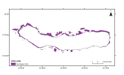
Interpretation of seismic sub-bottom profiles. Quartau, R., F. Curado, H. Duarte & C. Pinto, 2006. Projecto GEMAS ÔÇô Localiza├º├úo e distribui├º├úo de areias em redor da ilha de S. Miguel. Relat├│rio T├®cnico INGMARDEP 02/2006, Dept. Geologia Marinha - INETI, I.P., Lisboa.
-
Flores rock substrate from seismic subbottom profiles interpretation. (Bates, C.R., 2005. Sub-Bottom Profiling for Sand Resource Assessment, Flores Island, Azores. Team Internal Report 05-04)
-
Flores rock substrate from seismic subbottom profiles interpretation. (Bates, C.R., 2005. Sub-Bottom Profiling for Sand Resource Assessment, Flores Island, Azores. Team Internal Report 05-04)
-
Monte da Guia substrate map (Faial island). Neto, A.I., & I. Tittley. 1995. Stucture and Zonation of Algal Turf Communities on the Azores: a Numerical Approach. Boletim do Museu Municipal do Funchal, Sup. No. 4:487-504.
-
Vila Franca do Campo Islet Marine Reserve. The western side of the lagoon possesses a crescentic sand bank as a result of interacting wave inputs. The southern half of the lagoon comprises a rocky shelf. Offshore, the lagoon floor is dotted with ÔÇ£maerlÔÇØ (Morton, 1990).
-
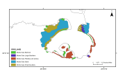
Spatial distribution of the dominant benthic macroalgae resulting from predictive models for the infralittoral rocky seafloor around Faial island and neighbouring passage to Pico. Tempera, F. (2008). Benthic Habitats of the Extended Faial Island Shelf and their Relationship to Geologic, Oceanographic and Infralittoral Biologic Features. Ph.D. thesis. University of St. Andrews. 348 pp. http://hdl.handle.net/10023/726.
-
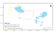
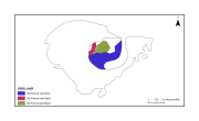
Historical habitats map for Lucky Strike substrate map (Mid-Atlantic Ridge). The Lucky Strike segment, located southwest of the Azores Islands, is 60 km long. Yellows domains correspond to areas with abundant inferred hydrothermal edifices and sulfide debris, where active and dead chimneys have been observed. Blue domains correspond to domains where hydrothermal activity is inferred based on scarce dive data. Black contour is the limit of the lava. Ondr├®as, H., M. Cannat, Y. Fouquet, A. Normand, P. M. Sarradin, and J. Sarrazin (2009), Recent volcanic events and the distribution of hydrothermal venting at the Lucky Strike hydrothermal field, Mid-Atlantic Ridge, Geochem. Geophys. Geosyst., 10, Q02006, doi:10.1029/2008GC002171.